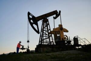
Pipeline operators often need to map the location of their pipelines, in order to determine if the pipelines have moved.
Mapping technologies available have typically used either the electromagnetic field (EMF) or ground penetrating radar (GPR). Both of these have limitations:
-
- EMF is operated by a technician and is subject to human error, so the precision of mapping is not always accurate.
- GPR has constraints related to physical conditions. For instance, it won’t work if the ground is too uneven or conditions are too wet.
Skipper NDT is a technology from France that is able to precisely locate pipelines laterally and horizontally under all types of terrain, using hardware fitted onto a drone. The drone payload consists of the following:
-
- Five 3-component fluxgate magnetometers
- A real time Global Navigation Satellite System (GNSS) receiver
- A tactical-grade Inertial Measurement Unit (IMU)
- An electronic card for data acquisition, digitalisation and synchronisation
We spoke with Maher Kassir, Co-Founder of Skipper NDT, who explained more about the technology.
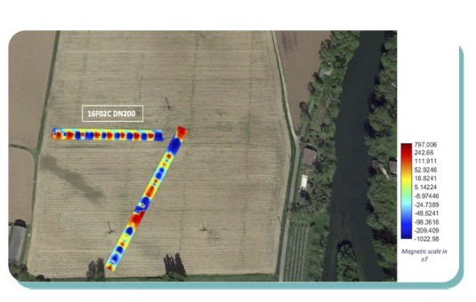
“The drone is flown several times across a rectangular area and is able to create a magnetic map showing the precise location of the pipeline,” said Kassir. “In addition, the map shows any metallic objects, such as another pipeline or electric wires, which cross the pipeline, as well as anomalies such as strain.” A combination of high frequency and low frequency maps is produced to help ensure accuracy.
Skipper NDT was tested over a two-year period in France, on pipelines ranging from three inches to 48 inches in diameter, across different terrains, such as under high voltage lines, near train rails and over cultivated crops. Tests resulted in a one-foot precision at almost 90 per cent, and a one-to-two-foot precision at 90 per cent. Furthermore, several pilots were successfully conducted with major pipeline operators in North America.
There are some limitations with the technology: it can only detect metallic pipelines and the right-of-way needs to be accessible about 15 feet on either side of the pipeline. “If parallel pipelines are less than 15 feet apart, that compromises accuracy,” said Kassir, “but this constraint will be solved by the end of the year”.
Pipeline operators typically have one or more of the following three primary objectives in identifying the location of buried pipelines:
-
- Quantify the depth of cover to mitigate external interference
- Identify areas where strain has been placed on pipelines due to ground movement, for instance at river crossings, on unstable slopes or in areas of frost heave and thaw settlement
- Update the Geographic Information System of the pipeline network, namely on water crossings
Skipper NDT advantages
Compared to alternative technologies, Skipper NDT has the following advantages:
-
- Highly precise
- Efficient and non-labour intensive
- Rapid mapping of large areas – on average, less than 30 minutes for a 300-foot water crossing
- Safe to operate
- Minimal logistical impact – inspection is carried out remotely without contacting the pipeline or interfering with the flow of materials inside the pipeline
- Effective on all metallic pipelines, regardless of the type of polymeric coatings used
Kassir added, “Bend assessment is an important application for Skipper NDT. We consider our technology to be a complement to inline inspection because, while ILI is very precise, it is expensive to launch on a regular basis and it interrupts the flow in the pipeline. Skipper NDT is a first diagnostic tool.”
The Pipeline Research Council International (PRCI) recently validated the technology. A precise geolocation was required on a pipeline to be retrofitted with fibre optics. Skipper NDT was able to provide an average depth of cover with a precision of 3.5 inches.
Energy Connections Canada members like Skipper NDT are providing an invaluable service in accurately monitoring and evaluating ground movements. Check out this recent post on the use of fibre optics for another example of how our industry is making significant leaps using data and other decision making tools to advance pipeline safety.